The Top 100 Most Expensive ZIP Codes in US by Forbes in 2013-Rank no.9-94028, Portola Valley, CA
The Top 100 Most Expensive ZIP Codes in US by Forbes in 2013-Rank no.9-94028, Portola Valley, CA
Rank no.9. 94028, Portola Valley, CA
Estimated zip code population in 2011: 6,740
Zip code population in 2010: 6,534
Zip code population in 2000: 6,595
Portola Valley is an incorporated town in San Mateo County, California, United States. The population was 4,353 at the 2010 census. It was named for Spanish explorer Gaspar de Portolà, who led the first party of Europeans to explore the San Francisco Peninsula, in 1769.
Portola Valley is one of the top forty wealthiest towns in the United States of America, with a median household income of $244,771 a year. Within the State of California, Portola Valley is ranked as the sixth wealthiest place. The zip code 94028, which encompasses the whole of Portola Valley, has the 31st most expensive housing prices within the country according to Forbes Magazine 2010.
Geography
Portola Valley is located at 37°22′30″N 122°13′7″W (37.375023, -122.218635)[3], on the eastern slope of the Peninsula Coastal Range of the Santa Cruz Mountains. The Windy Hill Open Space Preserve is on the town’s southwest side and the Jasper Ridge Biological Preserve is on the north side of town. It is off Interstate 280, near Woodside, just west of Palo Alto and Los Altos and south of Menlo Park, and is in a mostly wooded area, with some open plains.
According to the United States Census Bureau, the town has a total area of 9.1 square miles (24 km2), 99.98% of it land and 0.02% of it water.
Demographics
2010
The 2010 United States Census[4] reported that Portola Valley had a population of 4,353. The population density was 478.7 people per square mile (184.8/km²). The racial makeup of Portola Valley was 3,960 (91.0%) White, 12 (0.3%) African American, 5 (0.1%) Native American, 242 (5.6%) Asian, 1 (0.0%) Pacific Islander, 29 (0.7%) from other races, and 104 (2.4%) from two or more races. Hispanic or Latino of any race were 175 persons (4.0%).
The Census reported that 4,309 people (99.0% of the population) lived in households, 9 (0.2%) lived in non-institutionalized group quarters, and 35 (0.8%) were institutionalized.
There were 1,746 households, out of which 518 (29.7%) had children under the age of 18 living in them, 1,149 (65.8%) were opposite-sex married couples living together, 70 (4.0%) had a female householder with no husband present, 35 (2.0%) had a male householder with no wife present. There were 37 (2.1%) unmarried opposite-sex partnerships, and 21 (1.2%) same-sex married couples or partnerships. 420 households (24.1%) were made up of individuals and 290 (16.6%) had someone living alone who was 65 years of age or older. The average household size was 2.47. There were 1,254 families (71.8% of all households); the average family size was 2.93.
The population was spread out with 1,001 people (23.0%) under the age of 18, 145 people (3.3%) aged 18 to 24, 538 people (12.4%) aged 25 to 44, 1,496 people (34.4%) aged 45 to 64, and 1,173 people (26.9%) who were 65 years of age or older. The median age was 51.3 years. For every 100 females there were 98.4 males. For every 100 females age 18 and over, there were 91.2 males.
There were 1,895 housing units at an average density of 208.4 per square mile (80.5/km²), of which 1,392 (79.7%) were owner-occupied, and 354 (20.3%) were occupied by renters. The homeowner vacancy rate was 1.0%; the rental vacancy rate was 9.8%. 3,702 people (85.0% of the population) lived in owner-occupied housing units and 607 people (13.9%) lived in rental housing units.
Houses and condos: 2,743
Renter-occupied apartments: 510
% of renters here: 20%
State: 45%
Mar. 2012 cost of living index in zip code 94028: 143.7 (very high, U.S. average is 100)
Land area: 15.2 sq. mi.
Water area: 0.1 sq. mi.
Population density: 442 people per square mile
(low).
Real estate property taxes paid for housing units in 2011:
This zip code: 1.0% ($9,739)
California: 0.8% ($2,907)
Median real estate property taxes paid for housing units with mortgages in 2011: $10,001 (1.0%)
Median real estate property taxes paid for housing units with no mortgage in 2011: $7,992 (0.8%)
Zip code 94028 compared to state average:
- Median household income significantly above state average.
- Median house value significantly above state average.
- Unemployed percentage below state average.
- Black race population percentage significantly below state average.
- Hispanic race population percentage significantly below state average.
- Median age significantly above state average.
- Foreign-born population percentage significantly below state average.
- Renting percentage below state average.
- Number of rooms per house above state average.
- Percentage of population with a bachelor’s degree or higher significantly above state average.
Urban population: 5,663
Rural population: 1,076
| 94028: | $1,000,001 |
| California: | $355,600 |
Estimate of home value of owner-occupied houses/condos in 2011 in zip code 94028:
$25,000 to $29,999: 12
$175,000 to $199,999: 26
$250,000 to $299,999: 38
$300,000 to $399,999: 43
$500,000 to $749,999: 42
$750,000 to $999,999: 31
$1,000,000 or more: 1,854
Rent paid by renters in 2011 in zip code 94028:
$450 to $499: 53
$1,000 to $1,249: 116
$1,500 to $1,999: 22
$2,000 or more: 319
Median gross rent in 2011: $2,001.
Estimated median house (or condo) value in 2011 for:
White Non-Hispanic householders: $1,000,001
Asian householders: $1,000,001
Two or more races householders: $625,000
Hispanic or Latino householders: $1,000,001
Estimated median house or condo value in 2011: $1,000,001
94028: $1,000,001
California: $355,600
Lower value quartile – upper value quartile: $1,000,001 – $1,000,001
Mean price in 2011:
Detached houses: $1,317,056
Here: $1,317,056
State: $485,464
Townhouses or other attached units: $935,692
Here: $935,692
State: $404,738
In 5-or-more-unit structures: $140,635
Here: $140,635
State: $345,733
Races in zip code 94028:
White population: 5,658
Black population: 24
American Indian population: 6
Asian population: 385
Native Hawaiian and Other Pacific Islander population: 2
Some other race population: 11
Two or more races population: 141
Hispanic or Latino population: 307
Notable locations in zip code 94028:
Rancho Corte Madera
Pony Tracks Ranch
Portola Valley Town Hall
Portola Valley Branch San Mateo County Library
Woodside Fire Protection District Station 8
Churches in zip code 94028 include:
Woodside Priory
Ladera Community United Church of Christ
Valley United Presbyterian Church
Our Lady of the Wayside Roman Catholic Church
Christ Episcopal Church
Reservoirs:
Searsville Lake
Felt Lake
Creeks: Damiani Creek
Bull Run Creek
Corte Madera Creek
Bear Creek
Parks in zip code 94028 include:
Casa De Tableta State Historic Landmark
Jasper Ridge Biological Preserve
Frog Pond Park
Windy Hill Open Space
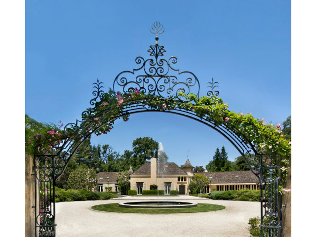
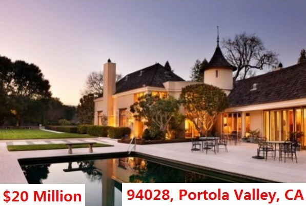
94028 Portola Valley, CA
21. 94028 Portola Valley, CA
Home: 1260 Westridge Drive
List Price: $20 Million
Listed With: Alain Pinel Realty
Source: Zillow.com
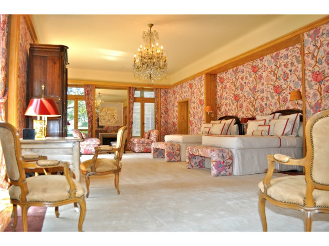
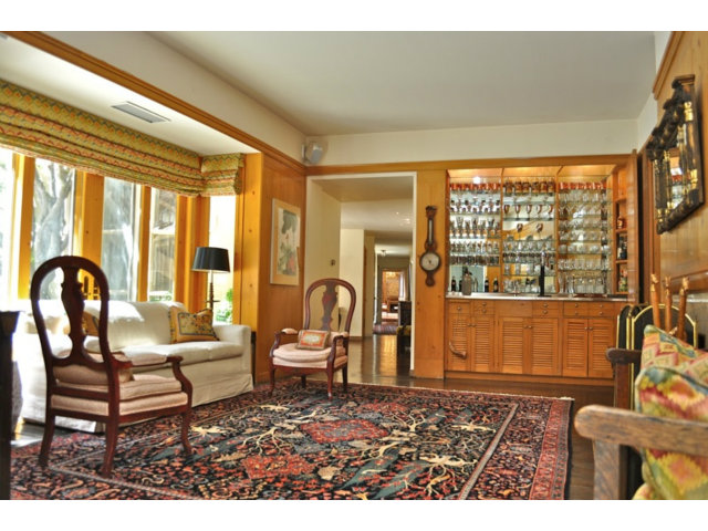
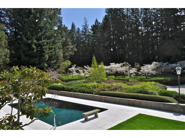
Description
| Price: | $14,750,000 |
| Bedrooms: | 4 |
| Bathrooms: | 5 |
| Size: | 8,285 sqft |
| $/sqft: | $1,780/sqft |
| Type: | Single Family House |
| Year Built: | 1957 |
| Lot Size: | 505,557 |
Image Gallery