
Top 100 Most Expensive Zip Codes in US by Forbes in 2013-Rank 14-94024, Los Altos Hills, CA
Top 100 Most Expensive Zip Codes in US by Forbes in 2013-Rank 14-94024, Los Altos Hills, CA
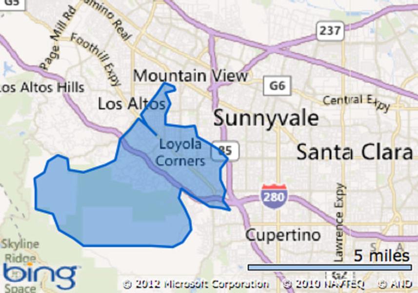
94024, Los Altos Hills, CA
Estimated zip code population in 2011: 22,448
Zip code population in 2010: 22,385
Zip code population in 2000: 21,479
Median Home Price: $2,680,591
Average Days On Market: 99
Number Of Homes On The Market: 17
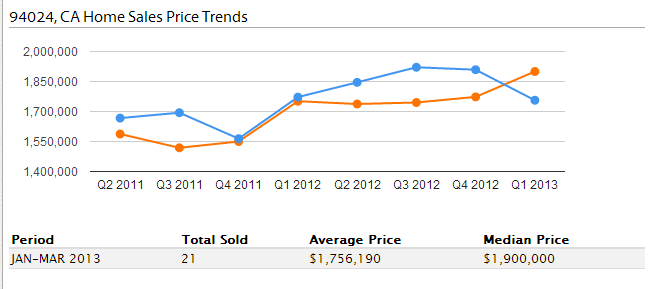
Recent home sales, real estate maps, and home value estimator for zip code 94024
Houses and condos: 8,049
Renter-occupied apartments: 709
% of renters here: 9%
State: 45%
Mar. 2012 cost of living index in zip code 94024: 136.6 (high, U.S. average is 100)
Land area: 7.3 sq. mi.
Water area: 0.0 sq. mi.
Population density: 3,075 people per square mile
(average).
Real estate property taxes paid for housing units in 2011:
This zip code: 0.9% ($9,115)
California: 0.8% ($2,907)
100% urban population.
Estimated median house/condo value in 2011: $1,000,001
94024: $1,000,001
California: $355,600
Estimated median household income in 2011:
This zip code: $166,125
California: $57,287
Housing units in zip code 94024 with a mortgage: 4,726 (82 second mortgage, 1,395 home equity loan, 46 both second mortgage and home equity loan)
Houses without a mortgage: 2,400
Median monthly owner costs for units with a mortgage: $4,001
Median monthly owner costs for units without a mortgage: $910
Residents with income below the poverty level in 2011:
This zip code: 1.8%
Whole state: 16.6%
Residents with income below 50% of the poverty level in 2011:
This zip code: 0.4%
Whole state: 9.4%
Median number of rooms in houses and condos:
Here: 7.2
State: 6.0
Median number of rooms in apartments:
Here: 4.8
State: 4.0
Estimate of home value of owner-occupied houses/condos in 2011 in zip code 94024:
$15,000 to $19,999: 16
$60,000 to $69,999: 7
$100,000 to $124,999: 55
$125,000 to $149,999: 72
$150,000 to $174,999: 10
$175,000 to $199,999: 8
$200,000 to $249,999: 30
$250,000 to $299,999: 13
$300,000 to $399,999: 51
$400,000 to $499,999: 59
$500,000 to $749,999: 106
$750,000 to $999,999: 387
$1,000,000 or more: 6,312
Rent paid by renters in 2011 in zip code 94024:
$350 to $399: 9
$500 to $549: 7
$1,000 to $1,249: 11
$1,250 to $1,499: 63
$1,500 to $1,999: 267
$2,000 or more: 264
No cash rent: 88
Median gross rent in 2011: $2,001.
Estimated median house (or condo) value in 2011 for:
White Non-Hispanic householders: $999,398
Black or African American householders: $1,004,825
Asian householders: $1,004,825
Some other race householders: $803,859
Two or more races householders: $938,304
Hispanic or Latino householders: $1,004,825
Estimated median house or condo value in 2011: $1,000,001
94024: $1,000,001
California: $355,600
Lower value quartile – upper value quartile: $1,000,001 – $1,000,001
Mean price in 2011:
Detached houses: $1,199,122
Here: $1,199,122
State: $485,464
Townhouses or other attached units: $653,394
Here: $653,394
State: $404,738
In 5-or-more-unit structures: $526,369
Here: $526,369
State: $345,733
Races in zip code 94024:
White population: 14,859
Black population: 103
American Indian population: 19
Asian population: 5,518
Native Hawaiian and Other Pacific Islander population: 27
Some other race population: 72
Two or more races population: 902
Hispanic or Latino population: 885
Housing units lacking complete plumbing facilities: 0.6%
Housing units lacking complete kitchen facilities: 0.9%
Zip code 94024 compared to state average:
Median household income significantly above state average.
Median house value significantly above state average.
Black race population percentage significantly below state average.
Hispanic race population percentage significantly below state average.
Median age significantly above state average.
Renting percentage significantly below state average.
Number of rooms per house above state average.
Number of college students below state average.
Percentage of population with a bachelor’s degree or higher significantly above state average.
Median real estate property taxes paid for housing units with mortgages in 2011: $10,001 (1.0%)
Median real estate property taxes paid for housing units with no mortgage in 2011: $4,958 (0.5%)
FACTS
Los Altos Listeni/lɔːs ˈæltoʊs/ is a city at the southern end of the San Francisco Peninsula, in the San Francisco Bay Area. The city is in Santa Clara County, California, United States. The population was 28,976 according to the 2010 census.
Most of the city’s growth occurred between 1950 and 1980. Originally an agricultural town with many summer cottages and apricot orchards, Los Altos is now an affluent bedroom community. Los Altos has several distinctive features. Commercial zones are strictly limited to the downtown area and small shopping and office parks lining Foothill Expressway and El Camino Real.
Forbes places Los Altos (area code 94022 and 94024) as the 63rd and 66th most expensive ZIP codes in the United States, behind such cities as Alpine, NJ, Atherton, CA, and Beverly Hills. This lists median home price around $2,000,000.
Los Altos means “the heights” or “foothill” in Spanish.
Geography
Los Altos is located at 37°22′5″N 122°5′51″W (37.36819, −122.097511)[5]. According to the United States Census Bureau, the city has a total area of 6.487 square miles (16.80 km2). All of it is land.
Topography
Los Altos is crossed by three creeks that flow north to San Francisco Bay, Adobe Creek on its western boundary, Stevens Creek on its eastern boundary and Permanente Creek in the middle. Hale Creek is tributary to Permanente Creek, and Permanente Creek is now largely diverted to Stevens Creek by a diversion channel. All three creeks originate on the flanks of Black Mountain.
Demographics
The 2010 United States Census[6] reported that Los Altos had a population of 28,976. The population density was 4466.8 people per square mile (1724.6/km2). The racial makeup of Los Altos was 20,459 (70.6%) White, 148 (0.5%) African American, 48 (0.2%) Native American, 6,815 (23.5%) Asian, 59 (0.2%) Pacific Islander, 195 (0.7%) from other races, and 1,252 (4.3%) from two or more races. Hispanic or Latino of any race were 1,132 persons (3.9%).
The Census reported that 28,749 people (99.2% of the population) lived in households, 34 (0.1%) lived in non-institutionalized group quarters, and 193 (0.7%) were institutionalized.
There were 10,745 households, out of which 4,067 (37.9%) had children under the age of 18 living in them, 7,476 (69.6%) were opposite-sex married couples living together, 599 (5.6%) had a female householder with no husband present, 228 (2.1%) had a male householder with no wife present. There were 199 (1.9%) unmarried opposite-sex partnerships, and 55 (0.5%) same-sex married couples or partnerships. 2,086 households (19.4%) were made up of individuals and 1,228 (11.4%) had someone living alone who was 65 years of age or older. The average household size was 2.68. There were 8,303 families (77.3% of all households); the average family size was 3.08.
The population was spread out with 7,560 people (26.1%) under the age of 18, 1,006 people (3.5%) aged 18 to 24, 5,273 people (18.2%) aged 25 to 44, 9,353 people (32.3%) aged 45 to 64, and 5,784 people (20.0%) who were 65 years of age or older. The median age was 46.2 years. For every 100 females there were 93.1 males. For every 100 females age 18 and over, there were 90.9 males.
There were 11,204 housing units at an average density of 1727.1 per square mile (666.9/km2), of which 9,002 (83.8%) were owner-occupied, and 1,743 (16.2%) were occupied by renters. The homeowner vacancy rate was 0.7%; the rental vacancy rate was 5.0%. 24,669 people (85.1% of the population) lived in owner-occupied housing units and 4,080 people (14.1%) lived in rental housing units.
History
The area was originally called Banks and Braes. Paul Shoup, an executive of the Southern Pacific Railroad, and his colleagues formed the Altos Land Company in 1906 and started the development of Los Altos. The company acquired 140 acres of land from Sarah Winchester. Shoup wanted to link Palo Alto and Los Gatos by making Los Altos a commuter town. It continued a train a day operation to and from San Francisco.
In 1908, Southern Pacific Railroad began running steam train service through Los Altos (April 19, 1908) with five trains per day. Two freight cars served as train depot. Also, the first commercial building, Eschenbruecher’s Hardware, was built in downtown.
In 1913, the craftsman-style Los Altos train station was built at 288 First Street.
By 1949, many residents were dissatisfied with the zoning policy of Santa Clara county. Also, there was a constant threat of being annexed by neighboring Palo Alto and Mountain View, so they decided to incorporate. Los Altos became the eleventh city in Santa Clara county on December 1, 1952.
Train service stopped its operation in January, 1964, and the train track became Foothill Expressway.
In 1976, Steve Jobs and Steve Wozniak, along with others including Ronald Wayne, built the first 50 Apple I’s in Jobs’s garage in Los Altos. Jobs, Wozniak, and Wayne founded Apple Computer, Inc on 1 April, 1976.
Design and planning
Los Altos strives to maintain a semi-rural atmosphere. Los Altos has few sidewalks except in commercial zones and along arterial roads. Minimum lot size for most residential housing is one-quarter of an acre. Most roads have broad dirt shoulders and little or no street lighting. The civic center sits in the middle of an orchard, a remnant of those that once covered the area. The downtown is a triangle with arterials on all sides that enable most through traffic to bypass Main Street. Many Los Altos homes fetch $2 million and higher, putting the city (along with neighboring Los Altos Hills, with which it shares ZIP codes) at numbers 24 and 28 on Forbes’ “Most Expensive ZIP Codes in America” list in 2007.
Since the mid-1990s, downtown Los Altos has experienced mild economic difficulties due to competition from nearby shopping centers and chain stores, as well as its lack of a hotel or movie theater. Revitalizing downtown is a major issue in city politics.
Los Altos may have a legitimate claim to having the first scientifically designed sound baffle in the year 1970. Santa Clara County undertook a seminal study to calculate the effects of alternate soundwall designs along Foothill Expressway. The resulting wall brought about the predicted reduction of seven to ten decibels in noise pollution levels experienced by adjacent homes.
Parades/Activities
Los Altos Kiwanis Club
Pet Parade (A Los Altos family favorite, the Pet Parade is held the first weekend in May and is full of dogs, cats, birds, horses and even some hamsters!)
Halloween Festival
Main Street Parade
Los Altos Rotary Club Fine Art Show
Downtown Los Altos Arts & Wine Festival, Los Altos Village Association
Downtown Los Altos Farmers’ Market, Thursdays 4–8 p.m., May through September, Los Altos Village Association
Los Altos Fall Festival, Los Altos Chamber of Commerce
California Country Annual Fall Antique Americana Show & Sale, June & October, Los Altos History Museum
Festival of Lights Parade (held the Sunday night of Thanksgiving weekend)
Los Altos High School Homecoming Parade (Happens every year on the Friday of LAHS’s homecoming week, usually in October. The parade features the Homecoming Court couples, LAHS Marching Band, Dance Team, Cheer Team, school board members and LAHS administration)
Notable locations in zip code 94024:
Los Altos Country Club
Santa Clara County Fire Department Loyola Fire Station
Los Altos-Woodland Branch Santa Clara County Free Library
Los Altos School District Office
Shopping Centers:
Rancho Shopping Center
Woodland Plaza Shopping Center
Los Altos Rancho Shopping Center
Churches in zip code 94024 include:
Saint Simons Catholic Church
Los Altos United Methodist Church
Los Altos Union Presbyterian Church
Foothill Baptist Church
Christ Episcopal Church
Creek: Hale Creek
Parks in zip code 94024 include:
Covington Mini Park
Grant Park
Heritage Oaks Park
Marymeade Park
McKenzie Park
Montclaire Park

94024 Los Altos Hills, CA
Home: 1121 Magdalena Road
List Price: $19.8 Million
Listed With: Alain Pinel Realtors
Source: Realtor.com