Alameda County, California
Alameda County, California
Description
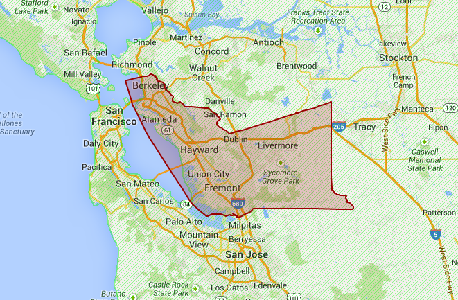
Alameda County is home to over 1.5 million people living in 14 incorporated cities as well as in six unincorporated communities and rural areas throughout the 813 square miles of the County.
The incorporated cities are Alameda, Albany, Berkeley, Dublin, Emeryville, Fremont, Hayward, Livermore, Newark, Oakland, Piedmont, Pleasanton, San Leandro, and Union City.
The unincorporated communities are Ashland, Castro Valley, Cherryland, Fairview, San Lorenzo, and Sunol.
County population in 2012: 1,554,720 (100% urban, 0% rural); it was 1,443,741 in 2000
County owner-occupied with a mortgage or a loan houses and condos in 2010: 232,188
County owner-occupied free and clear houses and condos in 2010: 59,054
County owner-occupied houses and condos in 2000: 286,306
Renter-occupied apartments: 253,896 (it was 237,060 in 2000)
% of renters here: 45%
State: 44%
Land area: 738 sq. mi.
Water area: 83.6 sq. mi.
Population density: 2074 people per square mile
(very high).
Mar. 2012 cost of living index in Alameda County: 132.2 (high, U.S. average is 100)
Races in Alameda County, California:
White Non-Hispanic Alone (34.1%)
Asian alone (25.9%)
Hispanic or Latino (22.5%)
Black Non-Hispanic Alone (12.2%)
Two or more races (4.0%)
Native Hawaiian and Other Pacific Islander alone (0.8%)
Geography
The reconstructed mission at Mission San José (located in Fremont).
According to the 2000 census, the county has a total area of 821.15 square miles (2,126.8 km2), of which 737.57 square miles (1,910.3 km2) (or 89.82%) is land and 83.57 square miles (216.4 km2) (or 10.18%) is water.
The San Francisco Bay borders the county on the west, and the City and County of San Francisco, California has a small land border with the city of Alameda due to land filling.[5] The crest of the Berkeley Hills form part of the northeastern boundary, and reach into the center of the county. A coastal plain several miles wide lines the bay; it is home to Oakland and the most populous regions. Livermore Valley lies in the eastern part of the county.
The Hayward Fault, a major branch of the San Andreas Fault to the west, runs through the most populated parts of Alameda County, while the Calaveras Fault runs through the southeastern part of the county.
Incorporated cities
Alameda, a charter city formed in 1916
Albany, incorporated as the City of Ocean View in 1908, renamed Albany in 1909
Berkeley, incorporated 1878
Dublin, initially the Murray Township (1868), incorporated as Dublin in 1982
Emeryville, incorporated 1896
Fremont, incorporated 1956, combining the former communities of Centerville, Niles, Irvington, Mission San Jose, and Warm Springs
Hayward, named as early as 1852, chartered as Haywards in 1876, incorporated as Hayward in 1928
Livermore, incorporated 1876
Newark, incorporated 1955
Oakland, incorporated 1852
Piedmont, incorporated 1907
Pleasanton, incorporated 1894
San Leandro, incorporated 1872
Union City, incorporated 1959
Unincorporated communities
The unincorporated communities in Alameda County are governed directly by the county. Alameda County has 6 major unincorporated communities that qualify as census designated places (CDP):
Ashland, east of San Leandro
Castro Valley, north of Hayward, east of San Leandro
Cherryland, north of Hayward
Fairview, north of Hayward
San Lorenzo, south of San Leandro, north of Hayward
Sunol, east of Fremont
Alameda County is the seventh most populous county in California, and has 14 incorporated cities and several unincorporated communities. The total population is estimated to be 1,510,271 as of April 2010, a 4.6% increase from April 2000. During the same time period, California’s population rose 10%.
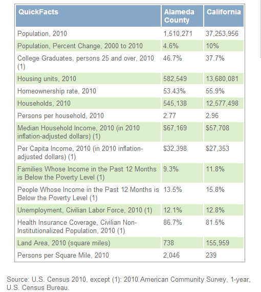
Alameda county is located close to the center of California. Alameda county has 739.02 square miles of land area and 82.31 square miles of water area. As of 2010, the total Alameda county population is 1,510,271, which has grown 4.61% since 2000. The population growth rate is much lower than the state average rate of 9.99% and is much lower than the national average rate of 9.71%. Alameda county median household income is $69,384 in 2006-2010 and has grown by 24.02% since 2000. The income growth rate is higher than the state average rate of 21.51% and is higher than the national average rate of 19.17%. Alameda county median house value is $590,900 in 2006-2010 and has grown by 94.95% since 2000. The house value growth rate is higher than the state average rate of 75.37% and is much higher than the national average rate of 50.42%. As a reference, the national Consumer Price Index (CPI) inflation rate for the same period is 26.63%. On average, the public school district that covers Alameda county is close to the state average in quality. The Alameda county area codes are 408, 415, 510, 650, 925.
Population 1,510,271 (2010), rank #7
Population Growth 4.61% since 2000, rank #41
Population Density: 1,838.82/sq mi, rank #4
Median Household Income: $69,384 at 2006-2010—24.02% increase since 2000, rank #10
Median House Price: $590,900 at 2006-2010—94.95% increase since 2000, rank #7
Time Zone: Pacific GMT -8:00 with Daylight Saving in the Summer
Land Area: 739.02 sq mi, rank #49
Water Area: 82.31 sq mi (10.02%), rank #24
State: California
Area: San Francisco-Oakland-Fremont, CA
School District:
Area Code: 408, 415, 510, 650, 925
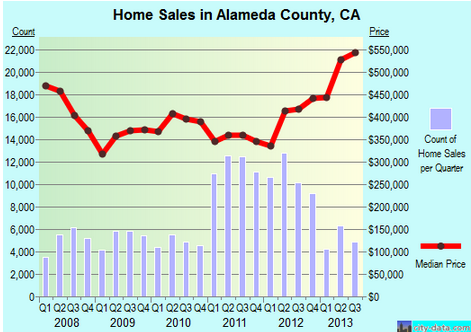
As of 2006-2010, median price of a house in Alameda County is $590,900, which is higher than the state average of $370,900 and is much higher than the national average of $179,900. The Alameda County median house value has grown by 94.95% since 2000. The growth rate for the price of a house in Alameda County is higher than the state average rate of 75.37% and is much higher than the national average rate of 50.42%. The median year that a house in Alameda County was built is 1966, which is older than the median year for a house built in the state which is 1973 and is older than the median year for a house built in the USA which is 1975.